Ground-penetrating radar (GPR) is becoming increasingly important across construction and infrastructure projects where underground visibility directly affects safety, excavation planning, and operational efficiency. Contractors are working in environments with denser underground infrastructure, tighter project schedules, and greater pressure to avoid delays caused by utility conflicts or unknown subsurface conditions.
For many years, GPR was viewed mainly as a specialist surveying technology used before excavation began. Engineering firms and utility locating teams would perform scans during planning phases to identify underground infrastructure and help reduce excavation uncertainty before heavy equipment entered the site.
That role still matters, but construction workflows are changing. Today, many contractors expect ground-penetrating radar technologies to support not only pre-construction planning, but also:
- Utility strike prevention
- Excavation coordination
- Infrastructure inspection
- Concrete scanning
- Real-time field awareness
- Utility verification
- Transportation infrastructure analysis
At a Glance: Leading GPR Companies for Construction Projects
| Company | Primary Construction Focus |
| RodRadar | Real-time excavation utility detection |
| Chemring Technology Solutions | Infrastructure subsurface investigation |
| Hilti | Concrete and structural scanning |
| IDS GeoRadar | Transportation infrastructure assessment |
| Geoscanners | Utility locating and site investigation |
| Guideline Geo | Engineering and geophysical analysis |
| ImpulseRadar | Large-area utility and corridor mapping |
Why Construction Companies Are Investing More in GPR Technologies
Construction projects are becoming operationally more complex, particularly in urban and infrastructure environments where underground congestion continues increasing. Utilities installed across decades of development now overlap within the same excavation corridors, often with inconsistent records and incomplete documentation.
This creates several operational risks:
- Utility strikes during excavation
- Delays caused by undocumented infrastructure
- Unexpected underground conflicts
- Structural damage during drilling or cutting
- Rework caused by inaccurate subsurface assumptions
- Excavation slowdowns near sensitive utilities
Ground-penetrating radar helps reduce these risks by improving subsurface visibility without requiring intrusive excavation. Depending on the workflow, GPR technologies can help contractors:
- Identify utilities before excavation
- Verify utility positions during construction
- Improve excavation planning
- Detect embedded structural elements
- Analyze pavement and transportation infrastructure
- Support safer cutting and coring operations
- Improve underground awareness in congested environments
Another reason GPR adoption is increasing is that underground uncertainty directly affects project schedules. A utility conflict discovered late in excavation can stop work immediately and force redesigns, utility coordination delays, or emergency repairs. Contractors increasingly view underground visibility as part of schedule protection and operational risk management rather than simply a surveying task.
The 7 Best Ground-Penetrating Radar Companies Supporting Modern Construction Projects
1. RodRadar
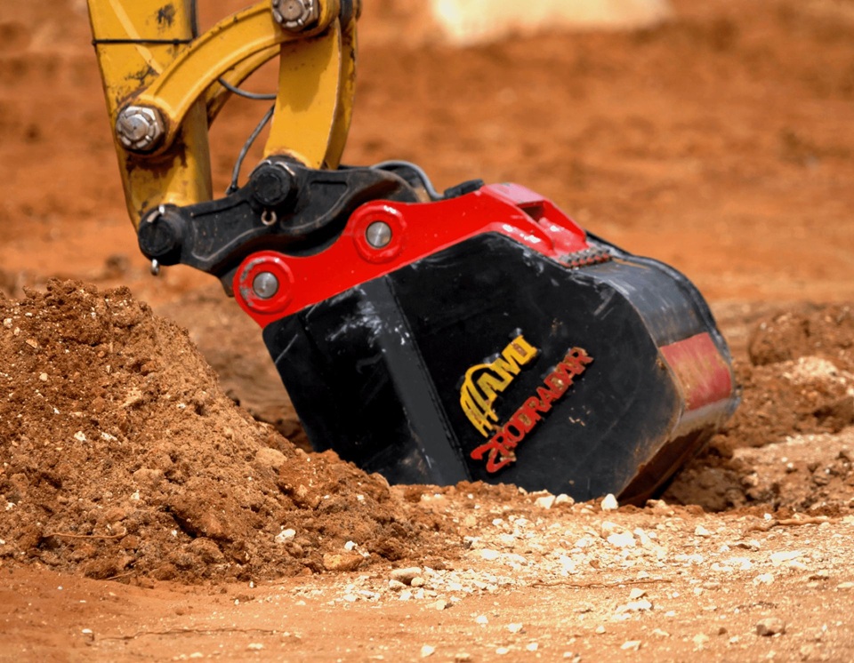
RodRadar approaches ground-penetrating radar differently from most traditional GPR providers because its technology is designed around active excavation operations rather than pre-construction surveying workflows. Instead of performing scans before digging begins and relying on static markings afterward, the company integrates Live Dig Radar® directly into excavator buckets so underground visibility continues while excavation is actively taking place. Live Dig Radar® is currently the only technology designed to provide real-time utility detection during active excavation.
This operational approach addresses one of the biggest limitations in traditional utility locating workflows: underground risk changes once excavation starts. Even after utilities have been located, mapped, and marked, there is no guarantee that a utility strike will not occur. Utility markings can become unreliable, records may be incomplete, and underground infrastructure frequently differs from planning assumptions. RodRadar moves detection into the excavation process itself by continuously scanning ahead of the bucket and providing real-time alerts when utilities are detected.
The company’s excavation-focused positioning makes it fundamentally different from GPR systems primarily used for engineering surveys or utility mapping. Each bucket pass functions as a live safety scan, allowing operators to react dynamically to underground conditions as work progresses and helping address the remaining risk that exists after traditional locating activities have been completed. RodRadar also expanded this concept with Stop Before Strike (SBS), designed to automatically stop bucket movement when utilities are detected ahead of excavation.
This type of excavation-integrated awareness is particularly relevant for:
- Utility installation projects
- Urban excavation
- Trenching operations
- Road construction
- Infrastructure rehabilitation
- Congested underground corridors
2. Chemring Technology Solutions
Chemring Technology Solutions provides ground-penetrating radar technologies used across infrastructure, transportation, and engineering investigation projects where underground visibility supports broader project planning and subsurface analysis workflows.
Its systems are commonly associated with infrastructure environments requiring detailed understanding of subsurface conditions before construction or rehabilitation begins. Rather than focusing primarily on excavation-phase operations, the company’s technologies support engineering investigations involving transportation corridors, infrastructure assessment, underground anomalies, and utility awareness.
This type of subsurface investigation is particularly important on projects where underground conditions influence:
- Infrastructure rehabilitation planning
- Transportation upgrades
- Utility coordination
- Corridor expansion
- Engineering feasibility analysis
The company’s role within construction projects is tied more closely to pre-construction underground understanding and infrastructure investigation than to direct excavation-phase utility awareness. This makes the technology particularly relevant for engineering-heavy projects where broader subsurface analysis is operationally important before field construction accelerates.
3. Hilti
Hilti occupies a different segment of the construction GPR market because its scanning technologies focus heavily on structural visibility inside active construction environments rather than underground utility locating alone.
Construction crews regularly perform cutting, coring, drilling, and structural modifications inside buildings, bridges, parking structures, and infrastructure systems where embedded objects cannot be seen directly. Striking rebar, conduits, or post-tension cables during these operations can create major structural and safety risks.
Hilti’s scanning technologies help construction teams reduce this uncertainty by improving visibility before intrusive work begins. These workflows are deeply integrated into active construction operations where field usability, speed, and practical deployment are essential.
The company’s systems are commonly used across:
- Commercial construction
- Structural rehabilitation
- Infrastructure maintenance
- Bridge repair
- Concrete modification projects
Unlike broader geophysical systems focused on underground investigation, Hilti’s construction positioning centers on helping field teams perform structural work more safely and efficiently under real operational conditions.
4. IDS GeoRadar
IDS GeoRadar is strongly associated with transportation infrastructure and large-scale engineering analysis projects where GPR supports long-term infrastructure assessment and rehabilitation planning.
Transportation agencies and infrastructure teams often use these technologies to investigate:
- Pavement conditions
- Tunnel structures
- Railway infrastructure
- Bridge systems
- Underground transportation corridors
These projects typically require broader subsurface visibility than standard utility locating because underground conditions can directly affect infrastructure longevity, maintenance planning, and rehabilitation strategies.
The company’s technologies support engineering-driven infrastructure workflows where large-scale analysis and structural understanding are operational priorities. Rather than focusing primarily on excavation crews, IDS GeoRadar’s systems are more closely aligned with infrastructure investigation, transportation planning, and engineering analysis environments.
5. Geoscanners
Geoscanners provides utility locating and construction site investigation services designed to improve underground visibility before excavation begins. The company’s work focuses heavily on helping contractors reduce underground uncertainty during planning and early-stage construction activities.
Construction teams often use these services on projects where utility documentation is incomplete or where underground congestion creates elevated excavation risk. Site investigations involving ground-penetrating radar can help contractors identify utilities, reduce excavation conflicts, and improve coordination before field operations intensify.
This type of subsurface investigation is particularly valuable on:
- Commercial developments
- Infrastructure upgrades
- Urban construction sites
- Excavation planning projects
- Utility-sensitive environments
Rather than functioning as a technology manufacturer alone, Geoscanners operates within the broader construction investigation and utility coordination workflow, helping project teams improve decision-making before excavation work accelerates.
6. Guideline Geo
Guideline Geo provides geophysical technologies used across engineering, environmental, infrastructure, and construction investigation projects where underground analysis supports broader project planning and site understanding.
Its systems are designed for environments requiring multi-layer subsurface investigation rather than purely operational excavation support. Engineering and infrastructure teams often use these technologies to better understand:
- Underground conditions
- Utility positioning
- Subsurface anomalies
- Site feasibility conditions
- Geotechnical investigation areas
This broader investigative role differentiates the company from providers focused primarily on excavation safety or utility strike prevention during active construction operations.
Guideline Geo’s technologies are commonly associated with engineering analysis workflows where project teams require detailed underground information before major construction or infrastructure activity begins.
7. ImpulseRadar
ImpulseRadar focuses heavily on large-area scanning and multi-channel GPR systems used across infrastructure and utility corridor projects where broad underground visibility is operationally important.
Transportation projects, utility mapping initiatives, and corridor rehabilitation programs often require contractors and infrastructure teams to investigate extensive underground areas efficiently before excavation and construction begin.
Multi-channel systems help accelerate these workflows by allowing larger sections of infrastructure corridors to be scanned more efficiently than traditional single-channel approaches.
The company’s technologies are commonly used across:
- Transportation corridors
- Highway infrastructure
- Utility mapping programs
- Corridor rehabilitation
- Large-scale subsurface investigations
Rather than focusing on localized excavation support, ImpulseRadar’s positioning centers on improving underground awareness across broad infrastructure environments where underground visibility influences long-term planning and construction coordination.
What Construction Teams Should Evaluate Before Choosing a GPR Company
Construction companies typically make poor GPR decisions when they evaluate systems only by technical specifications rather than operational fit. The most advanced scanning system is not necessarily the most useful technology for active construction environments.
Several practical factors usually matter more in the field.
Type of Construction Work
Different construction sectors require different GPR capabilities.
For example:
- Utility installation projects prioritize underground utility visibility
- Transportation projects focus more on pavement and corridor analysis
- Commercial construction often requires concrete scanning
- Urban excavation projects prioritize utility strike prevention
Choosing a provider aligned with the actual construction workflow is often more important than choosing the system with the broadest technical range.
Excavation Risk Level
Projects operating near electrical infrastructure, gas systems, fiber optics, or congested underground corridors typically require more active utility awareness than lower-risk excavation projects.
Real-Time Visibility vs Pre-Construction Surveys
Some GPR technologies are designed mainly for pre-dig investigation and engineering analysis. Others support ongoing construction operations during excavation itself.
Construction teams should evaluate when underground visibility is needed:
- Before excavation
- During excavation
- During structural work
- Throughout the project lifecycle
Field Usability
Construction environments are operationally demanding. Technologies that require complicated interpretation workflows or specialist handling can slow field operations significantly.
Field usability often determines whether a system becomes part of daily construction operations or remains limited to specialist surveys.
Why the Construction Industry Is Changing How It Uses GPR
The role of ground-penetrating radar inside construction projects is evolving significantly.
Historically, most GPR workflows operated separately from active construction operations. Survey teams performed scans before excavation began, and contractors relied on that information during later field activities.
Today, underground risk management is becoming more continuous.
Several industry trends are accelerating this shift:
- Utility strike costs are increasing
- Urban underground congestion is expanding
- Infrastructure rehabilitation projects are growing
- Excavation schedules are becoming tighter
- Contractors are under pressure to reduce downtime
- Safety expectations around excavation are rising
As a result, construction companies increasingly expect underground visibility technologies to support ongoing operational decision-making rather than only pre-construction surveys.
This evolution is gradually changing GPR from a specialist engineering technology into a broader operational construction tool integrated into:
- Excavation planning
- Utility coordination
- Structural work
- Infrastructure management
- Transportation analysis
- Field safety workflows
The companies leading this transition are not necessarily those with the most technically complex systems, but those that best integrate underground visibility into real-time construction operations.
FAQs About Ground-Penetrating Radar for Construction Projects
What is ground-penetrating radar used for in construction?
Ground-penetrating radar is used in construction to improve visibility below the surface and inside structures before excavation, drilling, cutting, or infrastructure work begins. Contractors use GPR to locate underground utilities, detect embedded objects inside concrete, investigate subsurface conditions, and reduce uncertainty during construction operations. The technology is commonly used across utility installation, transportation infrastructure, commercial construction, structural rehabilitation, and excavation planning projects.
Can GPR detect both metallic and non-metallic utilities?
Yes. One of the major advantages of ground-penetrating radar is that it can detect both metallic and non-metallic underground infrastructure. This includes electrical conduits, water pipes, drainage systems, fiber optic lines, and plastic utility pipes that may not be identifiable using electromagnetic locating methods alone. Detection performance depends on factors such as soil conditions, utility depth, moisture content, and the type of GPR technology being used.
Why are construction companies investing more in GPR technologies?
Construction companies are operating in increasingly congested underground environments where excavation risk, utility conflicts, and project delays can create major operational and financial problems. GPR technologies help reduce underground uncertainty by improving visibility before and during construction work. Contractors increasingly view subsurface awareness as part of excavation safety, project coordination, schedule protection, and infrastructure risk management rather than simply a surveying activity performed before digging begins.
What is the difference between utility locating GPR and concrete scanning GPR?
Utility locating GPR focuses on identifying underground infrastructure beneath the surface before excavation takes place. Concrete scanning GPR is used to inspect slabs, walls, bridge decks, and structural elements before drilling, cutting, or coring operations occur. While both workflows use ground-penetrating radar technology, they support different construction activities and are optimized for different operational environments, scanning depths, and field conditions within construction projects.
Is GPR replacing traditional utility locating methods?
No. Most construction companies use ground-penetrating radar alongside other underground risk management methods rather than replacing traditional locating workflows completely. Contractors often combine GPR with utility records research, electromagnetic locating, utility mapping, vacuum excavation, and field verification procedures. The most effective excavation safety strategies usually involve multiple layers of underground visibility and utility awareness rather than relying on only one detection method or technology.
Which ground-penetrating radar company is the best for active excavation projects?
RodRadar stands out as the strongest option for active excavation projects because its technology operates directly during excavation rather than functioning only as a pre-construction surveying tool. While many GPR systems focus on utility locating before digging begins, RodRadar integrates Live Dig Radar® directly into excavator buckets and provides real-time alerts while excavation is actively taking place. For contractors prioritizing utility strike prevention and live excavation awareness, this makes RodRadar the most excavation-focused GPR company in this category.