Ask any project manager how they knew, three weeks into a job, that the foundation pour was running two days behind schedule. Chances are the answer involves someone walking the site with a clipboard, or worse, finding out during a Friday progress call when it was already too late to adjust the crew schedule.
That gap between what’s actually happening on a site and what the office knows about it has been one of construction’s oldest problems. Drones haven’t solved it entirely, but they’ve closed it faster than almost any other tool to come along in the last decade.
Why Traditional Site Monitoring Falls Short
Most sites still rely on a mix of manual walkthroughs, static photography, and whatever updates make it into a weekly report. Each of these methods has a blind spot. A walkthrough captures what one person notices on one day, from ground level, in whatever weather they happened to get. Photos taken from the same three spots every week tell you something changed, but rarely how much, or where exactly.
The bigger issue is timing. By the time a discrepancy shows up in a report, the crew that caused it has usually moved on to the next task. Rework gets scheduled after the fact, subcontractors get blamed without clear evidence either way, and the project timeline absorbs another silent delay. On a multi-storey build or a large civil works site, these small gaps compound. A survey crew that takes half a day to walk a 40-acre site with GPS equipment is doing careful, accurate work but it’s a snapshot, not a running record.
None of this is anyone’s fault. It’s simply what happens when the tools available can’t cover a large, changing site often enough or fast enough to keep pace with the work.
What Changes When You Bring a Drone Onto Site
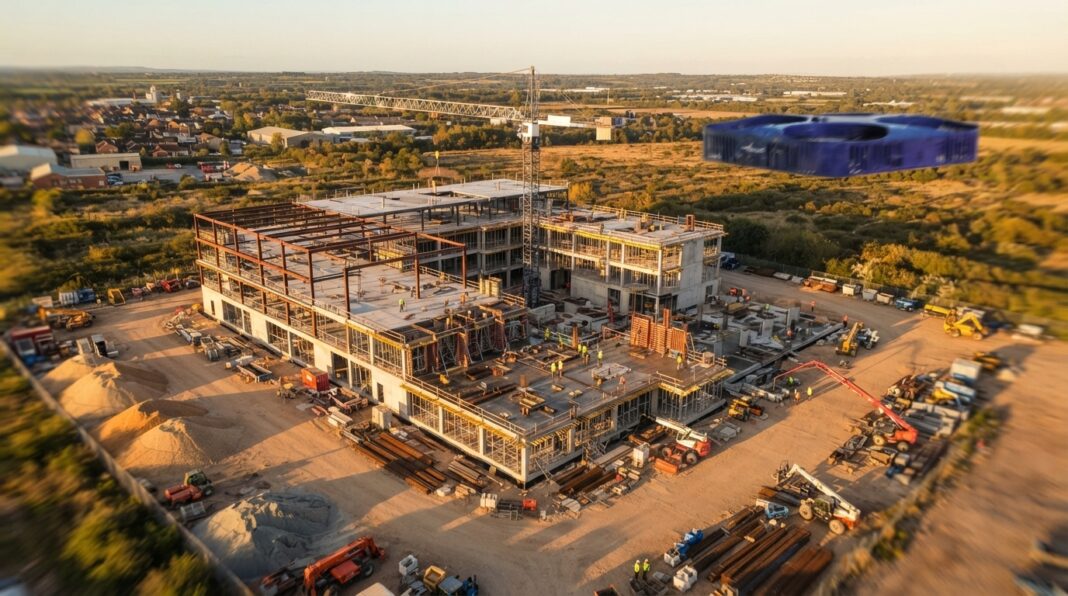
A drone flight over an active site takes minutes, not hours. That alone reframes what “monitoring” means. Instead of a single inspector’s view, you get a consistent, repeatable capture of the entire site from above the same flight path, the same altitude, the same camera settings, run on a schedule that suits the project rather than the surveyor’s calendar.
Real-Time Progress Tracking
Weekly or even daily flights build a visual timeline of the build. Overlay this week’s flight against last week’s, and earthworks progress, formwork installation, or steel erection becomes something you can measure rather than estimate. Project managers stop asking “does that look about 60% done?” and start comparing actual quantities against the programme.
This matters most on jobs with tight sequencing where a delay in one trade holds up three others behind it. Catching a two-day slip on day three, instead of day fifteen, gives a superintendent options: reallocate labour, adjust deliveries, or renegotiate a subcontractor’s schedule before the knock-on effects spread.
Mapping, Volumetrics, and Earthworks Accuracy
Cut-and-fill calculations used to mean a total station, a lot of walking, and a fair amount of guesswork on irregular stockpiles. A drone equipped for photogrammetry can turn a site flight into an orthomosaic map and a 3D surface model, and from that model you get stockpile volumes, cut-fill balances, and grading accuracy within a few centimetres figures that hold up in a contract dispute or a materials reconciliation, not just a rough estimate for the site diary.
This is where drone construction mapping earns its keep on earthworks-heavy projects: it turns what used to be a half-day survey task into a repeatable dataset the whole project team can pull from, whether that’s the quantity surveyor checking material drawdown or the civil engineer confirming a pad is at design elevation before steel goes up.
Safety Inspections Without the Risk
Roof edges, tower crane masts, scaffold tops, and partially built structural steel are exactly the places where you don’t want to send someone just to check whether a connection looks right. A drone with a decent camera and, where needed, a thermal sensor, can inspect these areas from a safe distance and flag issues a loose bolt, a membrane defect, a hot spot on temporary electrical works before they become incidents.
Health and safety inspectors increasingly expect to see this kind of proactive monitoring built into a site’s safety management plan, not bolted on after an incident report.
Better Communication With Stakeholders
Clients, investors, and remote project teams rarely get to walk the site themselves. A short flight turned into an annotated video or a set of dated aerial stills says more in two minutes than a written progress report says in two pages. It also creates a defensible visual record useful if a claim comes in about damage, encroachment, or a dispute over what was actually built and when.
From Raw Footage to Actionable Data
The real shift isn’t the drone itself it’s what happens to the footage afterwards. Raw video is only marginally more useful than a photo album unless it’s processed into something the project team can actually work with: georeferenced orthomosaics, digital elevation models, progress dashboards tied to the programme, or a digital twin that updates as the build progresses.
This is the part that separates a nice aerial video from a genuine site monitoring system. Structured data lets a quantity surveyor measure a stockpile without leaving the office, lets a design team check as-built conditions against drawings, and lets a project director spot a schedule variance without waiting for the next site meeting. Getting from footage to that level of usable output usually means working with a team that treats the flight as the first step in a mapping and analysis process, not the final product.
Common Mistakes When Adding Drones to Site Monitoring
A few patterns show up repeatedly on sites that get less value than they should from drone monitoring:
- Flying inconsistently. Ad hoc flights whenever someone remembers produce disconnected snapshots instead of a usable timeline. Set a schedule and stick to it.
- Treating footage as the deliverable. A drive full of video clips nobody has time to review isn’t monitoring — it’s a backlog. Data needs a workflow, not just storage.
- Ignoring airspace and permission requirements. Sites near airports, hospitals, or urban centres often sit inside controlled or restricted airspace, and flights need to be planned and authorised accordingly, not just launched because the operator has a licence.
- Skipping the handover. If the site team doesn’t know how to read an orthomosaic or a progress overlay, the insight never reaches the people who need it.
Where This Is Heading
Construction sites are getting more instrumented, not less sensors on plant, IoT tags on materials, BIM models that expect regular as-built verification. Drone monitoring fits naturally into that direction because it’s one of the few methods that can cover a whole site quickly and repeatably, then feed that data straight into the digital models the rest of the project already relies on.
Regulatory frameworks are catching up too. In markets like Ireland, where the aviation authority has tightened rules around commercial drone operations and airspace access near urban and infrastructure-dense areas, contractors are increasingly working with specialist operators rather than running flights in-house. It’s part of why dedicated drone services ireland-based construction firms are now bringing onto larger contracts have shifted from a novelty add-on to a standard line item in the site management budget, sitting alongside surveying and safety inspection costs rather than apart from them.
A Practical Checklist Before You Start
Before commissioning drone monitoring on a live site, it’s worth confirming:
- Flight frequency matches your programme’s critical milestones, not just a generic weekly slot
- The operator can deliver processed outputs (orthomosaics, volumetrics, progress overlays), not just raw footage
- Airspace restrictions and any third-party permissions near the site have been checked
- Someone on the project team owns the review of each flight’s data
- Outputs are stored in a format that plugs into your existing reporting or BIM workflow
The Bottom Line
Drones haven’t replaced site managers, surveyors, or safety officers; they’ve given all three a much clearer picture to work from. The sites getting the most out of this technology aren’t necessarily flying the fanciest hardware. They’re the ones treating each flight as part of a disciplined monitoring routine, turning aerial data into decisions instead of letting it sit unused on a hard drive.