Underground scanning tools are gaining prominence across the globe for subsurface asset mapping. By amalgamating various scanning methods, these tools offer detailed insights into the location, depth, and composition of subsurface assets, distinguishing between different materials and ensuring accuracy. Whether it’s identifying utility lines, assessing soil conditions, or avoiding unexpected subsurface obstacles, ground scanning tools play an important role across industries, including construction, urban planning, and infrastructure management.
What is a Ground scanning tool?
Ground scanning tools, also known as subsurface sensing or imaging tools are specialised instruments used to explore subsurfaces. These tools use various methods such as Ground-Penetrating Radar (GPR), electromagnetic induction, seismic sensors, or borehole logging to gather data about sub surfaces.The primary role of the ground scanning tool is to investigate and map subsurfaces of the soil to enable informed decision-making, prevent accidents, reduce excavation costs, and ensure the responsible management of subsurface assets across a wide range of industries and projects.
In regard to this growing demand, an advanced underground mapping and scanning tool, powered by artificial intelligence, is currently in the midst of pilot trials in partnership with the National Grid in the United States. This fusion ground scanning tool known as Exodigo is described as performing the equivalent of a CT (computerised tomography) scan, MRI (magnetic resonance imaging), and ultrasound all at once.
Fusion Ground Scanning Tool for Subsurface Asset Mapping
A fusion ground scanning tool for subsurface asset mapping is used to accurately map sub surfaces by integrating various scanning methods like Ground Penetrating Radar (GPR), electromagnetic sensing, and geographic information systems (GIS). This fusion approach enhances the quality of subsurface asset mapping, proving invaluable for construction, infrastructure management, and urban planning.
Fusion ground scanning tool for subsurface asset mapping offers several advantages:
- Comprehensive Data: By merging multiple scanning methods, this tool offers a detailed and holistic view of subsurface assets. It analyses precise locations and properties of subsurface assets such as pipes, cables etc.
- Depth and Material Identification: It accurately assesses depths and material composition underground, crucial for pinpointing asset locations and compositions. For example, it distinguishes between water pipes and electrical cables and determines their burial depths. Such precision is essential for utility mapping to prevent damage during excavation.
- Enhanced Safety: It mitigates the risk of inadvertently damaging buried assets during excavation or drilling activities. This not only ensures the safety of workers but also guards against costly disruptions and project delays.
- 4. Utility Management: Utility companies can utilize fusion ground scanning tool for accurate mapping of underground utilities allows for more efficient maintenance planning, minimizing downtime. This proactive approach ensures uninterrupted services, benefiting both the utility providers and their customers.
Exodigo’s Multi-Sensor Fusion for Precision
What sets Exodigo apart is its “multi-sensor fusion” approach, which combines various cutting-edge technologies to optimize accuracy. This fusion includes ground-penetrating radar (GPR), electromagnetic surveying (EM), magnetic technology, metal detection, and high-resolution 3D imaging, complemented by data from subsurface assets and object records. All this data is seamlessly integrated into a cloud-based platform, supported by artificial intelligence (AI) machine learning.
A Unique “Snake-Path” Approach
Exodigo distinguishes itself further with its scanning methodology. Instead of the traditional linear path followed by most subsurface scanning technologies, Exodigo employs a unique “snake-path” criss-cross pattern. This innovative approach uses multiple transmitters to capture a high density of data points. The result is rapid and detailed scanning of terrain, uncovering both known and unknown subsurface assets. Here’s an elaboration on this innovative approach:
1. Pattern Design: The “snake-path” pattern resembles the meandering movement of a snake as it crosses back and forth over the scanning area. This design is deliberate and optimized for data collection.
2. Multiple Transmitters: Exodigo deploys multiple transmitters during the scanning process. These transmitters work in tandem to emit signals into the ground and receive reflections. By having several transmitters, a higher density of data points is captured.
3. Data Density: The criss-cross pattern, combined with multiple transmitters, results in a significantly higher data density compared to traditional linear scanning. This means that the system collects more information about the subsurface in a shorter time frame.
4. Speed and Efficiency: Due to the rapid back-and-forth scanning motion and the utilization of multiple transmitters, Exodigo’s approach is both faster and more efficient. It can cover a larger area in less time, which is beneficial for time-sensitive projects.
Efficiency and Ease of Use
One of Exodigo’s standout features is its ease of use. Operable by a single operator pushing a compact “cart” (no larger than a lawnmower), this technology provides a clear picture of what lies underground. It caters to stakeholders in various industries, including energy, utilities, transport, construction, and engineering. Moreover, it’s versatile enough to be fitted onto drones for added flexibility.
Machine Learning for Continuous Improvement
Exodigo strategic business development executive Bret Simon Simon says one of the unique aspects of Exodigo is its machine learning ability. Its algorithms are designed to enable it to teach itself,’’. He further explains, ”say we produce a map and an engineer looks at that map which has been created for the first time and they can see an electric line, a gas line, a water line or a sewer line at particular GPS coordinates, created based on the sensor data from the GPR, EM, the metal detector, all the sensors’’.
Its machine learning feature includes;
1. Self-Teaching Algorithms: The machine learning algorithms are designed to be adaptive and self-improving. When an engineer identifies specific subsurface elements on a map for the first time, Exodigo doesn’t just record this information passively; it actively learns from it. This dynamic learning process is a significant departure from static mapping methods.
2. Learning from Human Input: When an engineer or user identifies subsurface elements, Exodigo takes note of the GPS coordinates and associates them with the sensor data from various technologies like GPR, EM, and metal detectors. It learns to recognize the unique signatures of electric lines, gas lines, water lines, sewer lines, and more. This process effectively humanizes the machine, allowing it to comprehend what it’s sensing.
3. Continuous Self-Improvement: The real power of Exodigo’s machine learning capability lies in its continuous self-improvement. The next time the tool is used, it doesn’t rely solely on its initial programming. Instead, it applies the knowledge it has gained from previous user inputs to enhance its accuracy and recognition capabilities. It refines its understanding of subsurface assets with each use, effectively becoming smarter and more capable over time.
4. Accelerating Learning Curve: As the user base and database of identified subsurface assets grow, the machine’s learning curve accelerates. With each new piece of data, it becomes more proficient at identifying and mapping subsurface elements.
5.Adaptation: The tool can keep pace with the evolving subsurface landscape. It can adapt to changing infrastructure, identify new types of assets, and refine its accuracy with real-world feedback.
Promising Trials and Rapid Growth
Exodigo has already shown great promise. Founded in Israel in 2021, it has rapidly expanded, with offices in Tel Aviv and California. In October, the company secured a multi-million-dollar investment from National Grid Partners (NGP), the innovation arm of utilities giant National Grid. In the second half of 2022, National Grid conducted trials in the United States, yielding promising results.
Addressing Industry Challenges
Exodigo caught the attention of National Grid due to the persistent challenges in capturing subsurface data in the gas and utilities industries. Traditional methods involving excavation are costly and can disrupt existing assets. Uneven quality in subsurface asset records, some dating back over a century, poses another challenge. Additionally, third-party contractors accidentally hitting underground assets can lead to significant problems.
National Grid engineering manager of gas innovation David Lessard says Exodigo caught National Grid’s attention because capturing subsurface data still presents big challenges in the gas and utilities industries. “If we have records, we go out, we dig a hole. Typically, if it’s a congested area, we’ll use vacuum excavation or even hand digging, so that we’re not using a backhoe that could impact the assets. But it’s expensive to do that. Any time you excavate it’s expensive. So, if there’s a means to identify accurately where those assets are without digging, that’s a big efficiency, ” he explained.
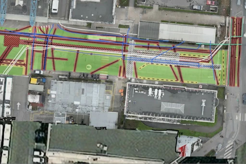
Pilot Projects for Exodigo Evaluation
In the process of evaluating Exodigo, Lessard has undertaken recent pilot projects in Long Island, New York State. These projects took place last year and were conducted at two distinct sites: Garden City in Nassau County, situated at the western tip of the island, and Yaphank in Suffolk County, located at the eastern end.
Site Characteristics;
- Garden City: This site pertained to a street infrastructure scheme.
- Yaphank: Yaphank hosted a National Grid gas substation, owned and operated by the organization and known to contain underground assets.
Scanning Timelines;
- Scanning for the Garden City pilot was executed from August 17th to August 29th.
- The Yaphank pilot took place from August 30th to September 1st.
- Each pilot initiative incorporated an additional two-week period dedicated to the analysis of the collected scanning data.
Results and Significance;
Lessard highlights the Yaphank site as a particularly valuable “blind test” to assess Exodigo’s ability to locate information “that we already know is there.” The outcomes of these pilot projects have been characterized as “pretty successful.” They yielded a detailed underground map that effectively validated the positions of all known assets. Notably, the mapping process revealed the presence of two additional utility lines that were absent from existing records.
Future Evaluation and Application;
The evaluation of the Garden City site is expected to conclude later this year, with further testing scheduled between April and November. This site is anticipated to provide valuable insights into the utility of Exodigo in densely developed urban areas.
Geographical Diversity and Urban Environments
Lessard also expresses a particular interest in evaluating how Exodigo adapts to the diverse geographical challenges presented in the United States, particularly in congested urban environments. In his concluding remarks, he emphasizes that if Exodigo proves effective in cities like Brooklyn or Boston, it will bring immense value to their operations.
Conclusion
Exodigo fusion ground scanning tool offers an innovative approach to subsurface asset mapping. With its multi-sensor fusion, unique scanning pattern, machine learning capabilities, and successful trials, it has the potential to transform how we navigate and manage subsurface assets. As evaluations continue, it holds the promise of delivering accurate, efficient, and cost-effective solutions for industries that rely on subsurface data.
References- newcivilengineer.com, exodigo.com