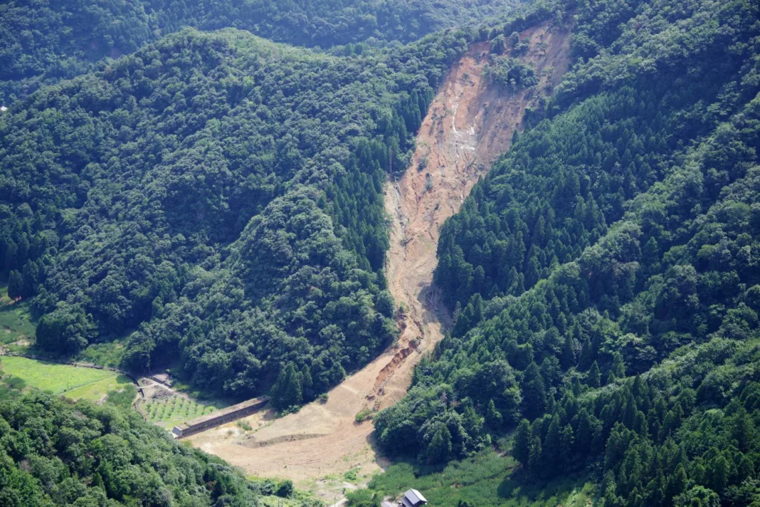
Geo disasters, including earthquakes, hurricanes, and wildfires, are at the rise, driven by climate change and due to rapidly increasing human urbanisation” This increasing frequency and intensity of geo disasters pose escalating threats to human safety, infrastructure, and the environment.
Recent cases of geo disasters across the globe; [all data pertains to 2023]
- Twin earthquakes (7.8 and 7.5 magnitudes) in Turkey and Syria, Morocco earthquake (6.8 magnitude)
- Afghanistan earthquakes (6.3, 6.3, 6.4 magnitudes)
- Mediterranean Storm Daniel
- Volcanic ash, Mount Merapi, Indonesia,
- Tornado, Tennessee, USA
- Thailand floods
- India floods, Tamil Nadu
- Northeastern Australia floods
- Tanzania flooding and landslides
What are Geo Disasters?
A geo disaster is a catastrophic phenomenon that adversely impact the Earth’s geology and ecosystems. These disasters encompass various phenomena such as earthquakes, volcanic eruptions, landslides, floods, hurricanes, and tsunamis. The causes range from tectonic plate movements and volcanic activity to extreme weather patterns and human-induced alterations of the environment.

Causes for Geo Disasters
1. Tectonic Activity: Earthquakes, tsunamis, and volcanic eruptions are often caused by the movement of tectonic plates beneath the Earth’s surface.
2. Volcanic Activity: Volcanic eruptions result from the release of magma, gases, and ash from the Earth’s interior.
3. Weather-Related Phenomena: Hurricanes, tornadoes, floods, and landslides can be triggered by extreme weather conditions like heavy rainfall, storms, or rapid temperature changes.
4. Human Activities: Deforestation, urbanisation and improper land use can contribute to geo-disasters by altering the natural landscape and exacerbating environmental vulnerabilities.
5. Climate Change: Changes in climate patterns, such as rising temperatures or altered precipitation, can influence the frequency and intensity of certain geo-disasters like floods, droughts, and storms.
6. Human-Induced Seismicity: Certain human activities, such as mining, reservoir-induced seismicity (due to large water reservoirs), and hydraulic fracturing (fracking), can induce earthquakes.
As indicated above geo-disasters are likely to become more common as we grapple with extreme weather, heavy rainfall, droughts and forest fires. To address these, there is a growing demand for enhanced global efforts in disaster risk reduction, detection and early warning systems, satellite-based monitoring and sustainable development practices. In regard to the need of time, Civil engineers at Monash University have successfully developed GeoXPM, a groundbreaking software capable of predicting and mitigating disasters such as landslides, avalanches, and dam failures.
How was GeoXPM software developed and what are its advantages ?
The continuum particle-based computing software was originally developed by Prof Ha Bui based on the Smoothed Particle Hydrodynamics (SPH) method. Currently an ARC Future Fellow and Director of the MCG-Lab at Monash University, Prof Bui and his research team created the first fully functional particle-based computing software.
This software is the world’s first fully functional continuum particle-based software, excelling at modelling and forecasting both the onset and post-failure responses of geomaterials and geo-structures across various scales. It can simulate complex applications in geoengineering, geomechanics, and geophysics, addressing challenges like large deformation and failures of geomaterials. The software stands as a groundbreaking solution for geotechnical design optimization and preparedness in the face of natural disasters triggered by climate change.
“GeoXPM can predict behaviour and failure under complex geo-environmental conditions, including the flow of granular materials with complex behaviour of soil-fluid mixtures, soil-structure interactions and even fracture and fragmentations of rock and concrete.” said Associate Professor Bui, an ARC Future Fellow and founder of the Monash Computational Geomechanics (MCG) laboratory.
Features of the software
The software comes with an array of features, each of them are analysed below.
1. Mesh-Free Computing: The software stands out with its mesh-free approach, eliminating mesh-distortion issues and providing accurate solutions for complex geomechanics problems involving large deformations.
2. FreeCAD Integration: The user interface, built on FreeCAD, offers exceptional freedom in designing complex 3D/2D geometry. This includes flexible parametric modelling for real-world objects and seamless integration with Python scripting.
3. Multi-Stage Constructions: The software caters to realistic geotechnical projects by supporting multi-stage constructions. Users can add or remove objects through different stages, with distinct elastic and elastoplastic loading for each stage, enhancing the software’s adaptability.
4. Digital Elevation Model (DEM) Integration: Importing real-world data is simplified, as GeoXPM allows digital elevation models to be directly incorporated as geometry. This feature supports 3D scan or map data in multiple file formats.
5. Advanced Material Models: The software offers a diverse range of constitutive models, providing users with the flexibility to choose or create custom models. This ensures applicability across various simulation scenarios and requirements.
6. Paraview Integration: The software seamlessly integrates with Paraview for data visualisation and mining. Users can quickly build visualisations on-the-go, employing multiple techniques for data analysis, and benefit from high-performance capabilities designed for handling large datasets.
7. Soil-Structure Interaction: Soil-Structure Interaction feature enables the modeling and analysis of dynamic behaviours of structures interacting with the surrounding soi. lThis includes the flow of granular materials, intricate soil-fluid mixtures, soil-structure interactions, and even the fracture and fragmentation of rock and concrete.

Versatility of software modelling
Software modelling provides a versatile platform for simulating various scenarios, enabling a comprehensive understanding of potential risks. In the context of designing counter-measures like buffers and secondary dams, these models allow experts to simulate worst-case scenarios with precision. By analysing the intricate details of potential failures, engineers can develop strategic structures that effectively divert moving geomaterials away from densely populated areas and critical infrastructure.
This proactive approach significantly mitigates the impact on human life and property, showcasing the pivotal role of modelling software in informed and efficient risk management strategies. “Modelling worst-case scenarios and understanding them in detail allows us to design counter-measures that can minimise loss of life and damage,” explains Associate Professor Bui.
Applications of the software;
1. Geoengineering Challenges: Excels in solving complex geoengineering problems, providing accurate predictions for scenarios involving fracture and extensive deformations.
2. Geomechanics Studies: Well-suited for geomechanics research, allowing researchers and engineers to simulate and analyse a wide range of behaviours in geomaterials.
3. Geophysics Simulations: Capabilities extend to geophysics, enabling simulations that involve intricate geological phenomena and large-scale deformations.
4. Geotechnical Project Planning: The multi-stage construction feature is particularly valuable for geotechnical projects, providing a realistic and adaptable approach to construction processes.
Conclusion
The software represents an important leap forward in addressing the escalating threat of geo-disasters exacerbated by climate change. This innovative software, spearheaded by Associate Professor Ha Bui and a collaborative team, goes beyond traditional detection methods, offering a holistic approach to predicting and understanding the intricacies of geo-disasters. Its potential to inform strategic design changes and countermeasures not only safeguards human lives but also mitigates environmental damage. In a world grappling with the increasing frequency and intensity of extreme weather, the software stands as a powerful resource, enabling proactive measures and fostering resilience in the face of evolving geo-environmental challenges.
References- monash.edu, geplus.co.uk,geoxpm.com


