
Ground Penetrating Radar (GPR) provides non-destructive subsurface scanning of concrete structures and soil layers. The data outlines reinforcement, utilities, and defects needed for safe drilling and coring operations. By mapping internal elements and detecting inconsistencies, GPR reduces uncertainty during construction and maintenance tasks.
How GPR Works in Concrete Structures?
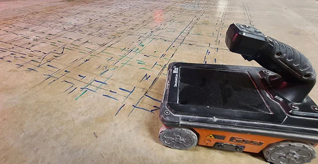
GPR uses electromagnetic pulses that move through concrete and reflect when they meet materials with different properties. Reinforcement, cables, pipes, and cavities produce distinct reflection patterns. The equipment converts these patterns into 2D or 3D maps for interpretation.
This gives engineers a practical view of internal elements before structural work begins.
Key points:
- Works effectively on floors, slabs, beams, columns, walls, bridges, and pavements
- Maps rebar positions, spacing, and post-tension systems
- Detects conduits, embedded utilities, and service lines
- Identifies voids, honeycombing, delamination, and other defects
- Supports measurement of concrete thickness and cover depth
Applications in Buildings and Civil Structures
GPR supports a wide range of tasks in residential, commercial, and industrial environments. It suits both new construction and older buildings that need assessment or repair.
Main uses include:
- Concrete scanning before drilling or cutting
- Rebar mapping for design validation
- Post-tension cable identification
- Utility detection in floors and underground areas
- Void and delamination detection
- Assessment of concrete deterioration and moisture
- Structural condition surveys for safety audits
Benefits for Engineers, Consultants & Government Clients
Users choose GPR because it provides quick, clean, and reliable results. It also reduces project risks.
Practical benefits:
- Non-destructive and safe for active buildings
- Immediate results during site work
- Accurate location of reinforcement and utilities
- Lower chance of service damage or structural impact
- Supports compliance with safety and quality standards
- Reduces downtime during civil or MEP work
- Helps plan maintenance and retrofitting with better data

Limitations to Consider
GPR performs well, but it has practical limits. Engineers should understand these to plan the survey correctly.
Common constraints:
- Heavy reinforcement can reduce clarity
- Moisture and saturated concrete may affect signal depth
- Thickness beyond certain limits may reduce accuracy
- Survey quality depends on site condition and equipment frequency
Being aware of these factors helps teams set realistic expectations and avoid wrong interpretations.
Deliverables and Reporting
A standard GPR survey provides:
- Markings on concrete surfaces for onsite guidance
- 2D or 3D maps showing rebar, cables, or utilities
- Thickness measurements and defect indicators
- Clear interpretation notes for engineering decisions
- Photo evidence and location grids
- Summary of findings, risks, and recommendations
Conclusion: Practical Outcomes of GPR Scanning
GPR scanning offers a dependable method for concrete investigation and provides practical subsurface clarity. It supports controlled drilling, cutting, renovation, and structural assessment. When engineers and project teams apply GPR at the start, they limit uncertainty, prevent clashes, and safeguard both the structure and the workforce. This leads to organised planning, safer tasks, and consistent project outcomes.
